
Up early. I stuffed the essentials in my pack and everything else under a rock, in case the rain came before my cure for summit fever. Hiking by 5:30am, munching Pop Tarts on the move, trying to beat any thunderstorms keen to repeat the excitement of yesterday. The sky was showing signs of warming color, but no cloud yet. Cool and clear. Summit ready.
Moving quickly to stay warm, I zigged up a sparsely-treed pile of scree before reaching larger stones of the moraine piled below the pass. The trail was as good as one can expect in this kind of terrain, easy enough to follow for the stumble bumble on undulating waves of broken rock interspersed with shreds of dirty snow. The final 400 vertical feet to the pass proved to be a bit more treacherous.
The trail unraveled into a braiding of crumbly use trails switchbacking haphazardly up a steep pile of gravel, right of the pass snowfield. It was clear that different routes became favorable as the snow melted throughout the spring, meaning that no routes were favorable. Just a big mess to the top. I was glad to not have anyone above or below for fear of dangerous dislodgings. Still, it was just a quick 10 minutes to the top at which point the trail returned to its normal self before finally traversing to pass proper. However, the snowfield lingered just enough to make this interesting. The roughly 30 yards of firm, morning snow that needed crossing would provide a literal slippery slope to a literal messy mangling. But the path was well boot tracked so careful going delivered me safely to the other side, followed a minute later by Shepherd Pass 12,000ft, 6:15am.

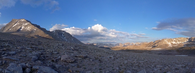
Clouds had crept back into the sky. I suppose a weatherman would have called it partly cloudy. Nothing worth worrying about yet and the additional dimension enhanced the morning light. Eastern edges of rock and cloud glowed in golden light with a sometimes gradual, sometimes sharp fade to shadow. This pattern repeated through a sweeping panorama from the nearby Mt. Tyndall across the barren Bighorn Plateau all the way to the Kaweahs on the far side of the Kern Valley.
My eye was inevitably drawn to Tyndall about a mile to the south, with its unmistakable ridged hump rising like a whale’s back from a sea of scree. The route looked to be in good shape. The morning shadow made the Northeast rib obvious, rising 1,000ft unimpeded to the summit ridge. It was free of snow. A straight shot, more or less. Feeling good, I left the trail to swim up the soft gravely ground on the final approach to the mountain. A snowfield made the going easier when the gravel turned a bit rocky, but this was about as smooth as trailless walking goes.

The scrambling started around 12,700ft at 6:50am. Classic Sierra class 3. Contending with a few loose rocks had me happy to have my helmet, but I made quick progress on the straightforward route without issue. The right side of the rib, near the snow where the rock was a bit more broken, provided plentiful holds and less exposure. Whew, the climbing was awesome. Many Sierra ascents involve an isolating chute or gully, enclosed on either side by rock walls, limiting the view. In contrast, the rib’s convexity afforded air and views at all moments. Enough air to take my breath away.
After 45 minutes and 850ft, the broken rock transitioned to layered slab. A slip here implied a longer tumble, but I admit that my mind enhanced the true danger. I carefully chose my moves up this section. A short traverse left followed from the top of the rib where a shorter chute brought me to a notch in the main ridge, 13,800ft. A small bit of snow was easily avoided. Almost 1,200ft of rib in about an hour of fun climbing.

Through the notch the world opened up, 180 additional degrees of vast playground. The massive south slope of Tyndall swept down over one thousand feet to the Wright Lakes Basin, giant peaks marked the southern border of the high Sierra across the horizon including 14ers Mt. Russell and Mt. Whitney. ‘Not Tyndall’ from my failed attempt on this mountain during the PCT was tantalizingly close just a half a mile west. As great as it was, the view would get better. An easy hop up the remaining 1/8th of a mile and 200ft of the west ridge put me on the summit of Mt. Tyndall, 14,018ft. A spectacular summit perched along the sharp edge of an El Capitanian vertical east face, which dropped 1,500ft to the Williamson Bowl below. Just before 8am.

Most of the clouds had cleared during the climb, allowing me a leisurely summit experience. I scampered around taking photos, signed the summit register, and ate some stuff. I also managed to thoroughly freak myself out by sludging up a boulder, and perhaps the true high-point, precariously perched like a diving platform above a very high dive indeed. After 50 minutes, it was time to roll out. Although the sky gave no indication of getting nasty, I felt compelled to beat the impending storms. No need to risk getting caught out like yesterday.

Reversing the route was easy. The slabby section was a little worse going down, but nothing I couldn’t crab walk. Lucky for me, the snowfield adjacent to the rib was just soft enough to attempt a glissade. With the spike of my ice axe firmly punched in, I scooched down the steep snow. Jamming my feet in every five feet or so helped minimize my momentum. However, even taking my time, I was down the final 350ft in 8 minutes. My butt would be numb for an hour, but skipping some fiddly death talus was worth it. Plus, I got to admire my impressive butt track left in the snow for all to see.

Regrouping clouds inspired me to book it, reaching the pass once more a little after 10am. 30 minutes later I was back in camp. Packed up 35 minutes after that. Chill. Moving again at 11:20am. The Hawaiian shirted geologist shouted congratulations from above the washout where he was directing the trail crew, but the troubled sky kept the exchange short and I boogied on.
The dark and threatening clouds stopped threatening and began doing at just after noon. It was warm back around 8,500ft so the rain dampened the dust, but not my mood. The trail crew’s second division shared my indifference as they enjoyed lunch, unperturbed. Clearly, this was nothing to them and maybe even a welcome respite from blazing, high-altitude sun. I filled my lungs with rich petrichor while trundling along under the protection of my umbrella. Lightning flashed behind me high along the eastern crest and thunder complemented the pitter-patter. Pleasant and harmless down here, terrifying and powerful up there.
Before that distressing 500ft climb to the saddle, I watched dark sheets of rain push east out into the desert, only to evaporate into nothing before reaching the hot gravel waste below. I would reach that hot gravel. 500ft up to the saddle then easy cruising down shady switchbacks. I was out of the rain now, but not by much. Roiling nimbus continued to darken and thunder continued to rumble. Not an afternoon to be high in the mountains. How does this compare to yesterday? Was it dumping inches of hail up there? I wasn’t too disappointed to leave that answer a mystery.
At 2:30pm I kicked through the sand back into the parking lot, quads a bit soft from the last 2,850ft descent to the valley floor. A world away from 14,018ft. Amazing where feet can take you. My car was half clean, probably from the storm yesterday. With today’s edition still raging, I was glad to be back down, knowing the alternative firsthand. Still, there was the familiar twinge of regret for leaving. For missing out. Wild energy. Blitzing a summit is has its perks, but they’re weak substitutes for those of a longer immersion. The weather showed up as promised. My risk mitigation efforts worked. I guess I nailed it? Or maybe I just got lucky. Either way it was a good climb. Thanks, Tyndall.

Hi Owen,Congrats
LikeLike
Sounds fun! I have fond memories of puking near the top of Shepherd’s pass back in 2011. I’ll have to come back for Tyndall.
LikeLiked by 1 person
Haha, “fond” memories. Yeah, dude, that was a sweet trip. Tyndall is definitely worth a return. We gotta get back out there sometime, brochacho.
LikeLike
I’m so down. I was at Cottonwood Lakes a few weeks ago and it just makes me want to spend more time in the eastern sierras.
LikeLiked by 1 person
Ooooo, some of my favorite stuff is around there.
Can’t beat the Eastern Sierra. The best place in the world.
LikeLike