
CDT Day 122 — October 25
Canjilon Creek to Mesa del Yeso
Last Coldest Day Camp to Hello Desert 2.0 Camp
Miles hiked: 25.6
Total miles: 2138.5
An incredibly pleasant day today. The morning was cold, but it wasn’t long in warming up. We started in the low mountain foothills, but ended up unquestionably in the desert. This transition was slow and took the entire 25 miles to appear, different phases easing us into it. The trail was smooth, though easy to lose at times, so SpiceRack and I cruised, enjoying the transition.
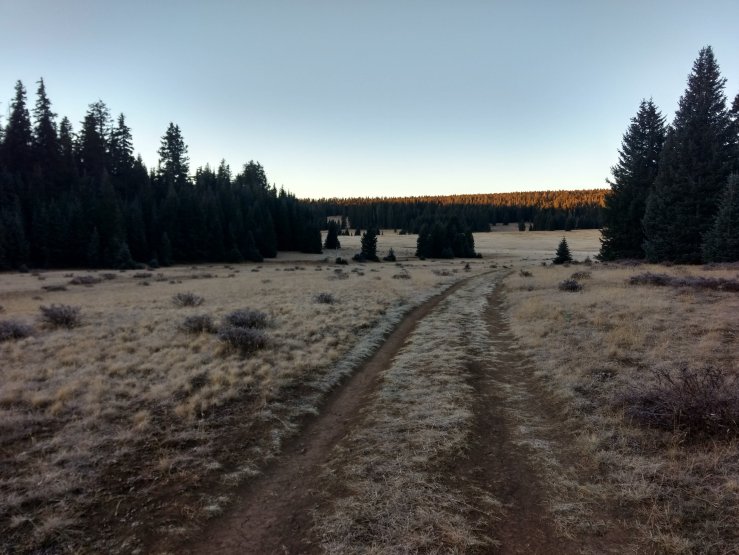
Another frigid morning at 10°F by the time we got moving around 7:20am. Orange glow tipped the trees as I followed Spice through frozen meadows, sparkling with huge frost crystals. Keeping my hands warm was a chore as I scarfed some bars for breakfast until reaching patchy sun on the gradual decent along Canjilon Creek. In a few miles we reached a picnic area with a perfectly timed privy and an abundance of warm sun. We laid out our water bottles to thaw, apply sunscreen, and remove layers.

We leapfrogged with two other hikers on the way out of the hills into an expansive landscape of pasture and scrub. Big mountains to the east had clearly caught a lot more snow than us yesterday, a cliffy escarpment to the west foreshadowed the coming desert. It was very cool to be in the middle. The sun was blazing now and it felt wonderful to be warm. I hiked in just my shorts and shirt for the first time in weeks, feeling like it was the first time I had taken off my pants since Pagosa.

Spice and I hiked through some more aspen, well past the autumn phase, then got confused by conflicting GPS data. I took a new trail while she stuck to the dirt road. In only a half mile I was already a quarter mile behind so I bushwhacked back to the road to leave that meandering nonsense behind. It was as if the trail crew that had built the trail were being paid by the mile. The switchbacks looping through the flat meadow were hilarious. I really don’t understand what happened there. Then we got lost a few times even on dirt roads, these ones disappearing sometimes altogether. It didn’t matter in the end, and corrections were easily made. We reached our junction to Ghost Ranch, the next resupply location, then plopped down for lunch yards later at a piped spring pouring yummy water into a trough. Water break. Lunch break.

For the first time in a while, I actually felt hungry. And it felt oh soooo good. Ever since Pagosa when the weather got really cold, I just have not been eating a lot. Frustrating because I’ve still carried the same amount of heavy food despite my lack of appetite in anticipation of a roaring comeback. When I weighed myself on a scale in Salida, I was already down to my PCT finishing weight. Since then we’ve been through the San Juans and a period of intense cold. I’m sure I was running a calorie deficit through those sections so I feel like I must have lost even more weight. I needed my hunger to return, and it seems like it has with the warm up. Excellent news. Time to pack on some pounds!

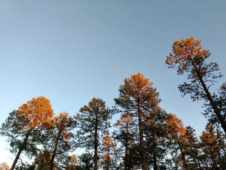
A peaceful ponderosa forest came next. I absolutely loved seeing these big trees again and they reminded me of home. The smooth dirt road allowed me to swivel my head between bark and tree tops while listening to a dense audiobook and savoring the scent of warm things again. Spice and I noticed we were a mile down the wrong road at a break, but pieced together a short detour to find trail again. It was actually a wide gravel road, and we followed it out of the forest and into the darkening desert transition zone full of sage and pinion pine.
We had planned on making it to the outskirts of Ghost Ranch to enable us to make it to the early morning breakfast buffet. Instead, we decided to camp earlier before the steep drop into a canyon, wanting to experience this last major climate transition of the trail in daylight. I was tired and ready to camp anyway. The warm sand was begging me to cowboy camp. And that’s what we did for the first time in a while. It felt amazing to be in the desert. Warm, like home and the last missing ingredient to this thru-hike. It wouldn’t feel right without it. The smell of sage fills the air and my lungs. ¡Viva la sage!

Yes aspen trees are glorious but nothing, nothing can ever rival pine trees for beauty and magnificence. Nothing. Maybe fir trees can come close and stand quietly beside. But I am quite sceptical even about that attempt. Ponderosa is the second tallest pine tree after sugar. Anyway… May I ask you why we are advised to unfasten hip and chest straps of a backpack while fording the streams? Yes it is said in order to prevent dragging you along if you fall. But on the other hand at the same time it is recommended to make backpack floatable i.e. bu putting all belongings in large sealed plastic bags (or maybe in something else Im not aware of other viable options).. so we want to detach it from ourselves quickly and simultaneously want to float on it?? Or we want it to float so as to we can find it later on… why do we make it buoyant in essence? I know i can find a thousand answers on the internet but I cannot neglect to mention it here. All other sources are other sources, but how am I to miss my chance to ask you?
LikeLiked by 1 person
You bring up a good point about unbuckling backpack straps. I’ve never questioned it myself, but I imagine that swimming with a backpack on, even if it’s buoyant, is way harder than without. If the bag floats that well, then wouldn’t it push a person underwater face-first if it were strapped tightly to their back? That’s the vision I have in my mind. I guess if you’re that curious you could try swimming with a pack on in a pool somewhere. Sounds kinda fun actually.
LikeLike
=DD Thank you for sharing the meandering nonsense. It is useful to know the locations of such places. I have heard many times how people are having a hard time to follow the trail in NM, repeatedly over and over. Finally I can see at least roughly & approximately on the map where are all these spots. ”as if paid by the mile” =DD it is too funny
LikeLike