
For those that want to access some of the highest terrain in the Sierra, Horseshoe Meadow is probably the easiest place to start. A paved road will take you all the way to 10,000 feet, where you can step out into a ridiculously beautiful alpine landscape that normally requires hours of sweaty effort to access. It will take your breath away, acclimatized or not. I had spent a night there before on my way to Whitney in 2008, but otherwise had wrongfully ignored this southern tail of the high sierra. With the weekend looming, I decided to finally do some exploring of Cottonwood Lakes Basin, popular for its numerous lakes and easy walking.
The drive to Horseshoe Meadow was predictably awesome. Switchbacking up a steep mountain with views improving the whole way, it felt like cheating to step out at Horseshoe Meadow after being in the Owens Valley less than an hour before. Ethics aside, the road put me in a beautiful place. I parked in the large lot at Cottonwood Lakes trailhead and sucked in the thin air.
Eager to see what I would see, I didn’t waste time starting up the wide trail through the trees. The walking was just about as easy as it can be above 10,000ft. While the trail is mostly flat, there is sand to contend with in spots as pack animals are used to supply a hidden away youth camp. But pleasant walking nonetheless, meandering through dispersed pine forest and granite lumps. Immediately after crossing the South Fork of Cottonwood Creek, I reached my first junction (mile 1.5, 10,045ft). The trail had been plenty busy until this point, with no shortage of fishermen out for the day and backpackers loaded for many days so I was happy to veer left off the main trail to find my own adventure, leaving them to theirs.
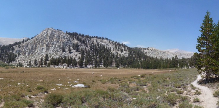
Though unmaintained, the Old Cottonwood Lakes Trail was easy to follow as it gently climbed, following the creek. South Fork Meadow offered good views of tree-stubbled granite lumps to the east. Wandering further, the trail all but disappeared with only a few cairns to mark the way as it climbed steeply to the next bench. Even without a trail at all, hiking was easy through widely spaced trees before I hit the main trail to South Fork Lake. A short cruise got me to the grassy shores where I settled in for a snack and watched a fisherman do his thing (mile 4.75, 11,000ft). Fantastic views of the wide basin’s rim and high granite peaks all around, including Mt. Langley to the north.
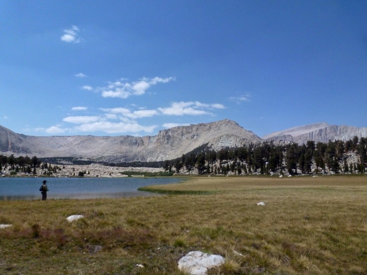
In no particular rush to get to camp, I made a quick excursion to Cirque Lake, yet another gorgeous spot with a sandy beach and ample camping, before leaving the trail to find my way to Long Lake. Except for one patch of pine, the terrain was open near Upper South Fork Lake, so navigational challenges were minimal cutting a straight line across grassy, then rocky, then soggy ground. I hit the main trail to New Army Pass, but hopped right over it to find a campsite at Long Lake. I settled in to cowboy camp with a view across the lake of the steep granite cliffs running from Cirque Peak on the left to New Army Pass on the right (mile 6.3, 11,160ft). I watched the consistent trickle of backpackers inching up and down the trail while being outsmarted by golden trout. Clouds blew in, but did not threaten. Dinner was prepared, but was not heated. Sleep.

I was feeling sprightly in the morning so I made the decision to check out New and Old Army Passes to satisfy my curiosity, before lake spotting on my way down Cottonwood Creek back to the car. The good trail soon brought me above the treeline after leaving Long Lake. High Lake came and went before dense switchbacks brought me up the final rocky slope to the New Army Pass (mile 8.8, 12,400ft). Expansive views penetrated deep into the mountains to the west across the Kern River to the Kaweahs, and north to some of the highest peaks in the state. To the south, my entire route thus far from Horseshoe Meadow was visible and then beyond to Olancha Peak. The weather was fine and I was ready for a swim, so I shouldered my pack to leave the popular spot.

Old Army Pass was easily reached down a gradual sandy slope (mile 9.4, 12,000ft). I could see the need for a New Army Pass. Hugging a north-facing cliff, Old Army would hold snow well after most trails melted out. Still, there was no snow today, so while steep, exposed, and rocky, the trail delivered me safely to the shores of 4th Lake is short order. After a leisurely lunch and swim, I continued past 5th and 3rd Lakes back on the main trail. All these lakes were big and beautiful with a mixture of forested and rocky shores, each worthy of their own trip. Sharp granite cliffs rimmed this upper corner of Cottonwood Basin.

At 3rd Lake, I cut left off the trail to find Muir Lake, just because. On the way, what appeared to be another large lake on the map turned out to be a small lake surrounded by a grassy plain, which made navigating through it much easier. Muir Lake was easily located after plunging into trees again and I enjoyed a second lunch while observing different groups of campers doing different things (mile 12.3, 11,140ft). Popular spot, but for good reason. Great camping around here.

I saddled up one final time to get a move on back to the trailhead. Locating the actual trail to Muir Lake, I bombed down to the junction with the main lakes trail on the edge of a wide meadow with the last great panorama of the basin. I gave a final twirl before descending back into the trees along Cottonwood Creek. Miles flew by, steady undulations trending gradually downhill through the trees past many people heading in with fishing rods and/or armfuls of sleeping bag. After closing the loop at the South Fork junction, it was just a familiar scoot to the trailhead (mile 17.6, 10,000ft). As hard as it was to leave after a perfectly pleasant, low-key trip, ice cream heals all wounds and all it took was an easy roll downhill to get it. I saw a lot, but still want to see more. With Cottonwood Lakes Basin so accessible, it won’t be long.

1 thought on “Cottonwood Lakes”