
There are no easy ways to get to Baxter Pass. There are no easy ways to get to Baxter Pass. There are no easy ways to get to Baxter Pass. Once this is a firm belief, one can focus on the things that matter. Baxter Pass is a crazy awesome place. Embrace the adventure of getting there. I wrote a tremendous introduction to this trip on the Baxter Pass page and I won’t try to improve it here. Start there if you like, or jump right in:
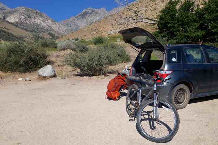
Car parked, bike assembled, pack on. I still had no idea where Baxter Pass was, one of the two drainages rising east to the Sierra Crest. I had to trust that the sign at the trailhead wasn’t mistaken and that I would actually be able to find this place whenever I made it out tomorrow. My Scion Xa was the only vehicle in sight, confirmation that this is one of the quietest trailheads in the Sierra. I was glad I brought my bike. No chance of hitchhiking from here. More fun than hitchhiking too. I bombed down the dirt road to the valley floor, barely pedaling at all. At Hwy 395 I took a right towards Independence, just a short 2 miles away. I locked up my bike, then stuck out my thumb on the road to Onion Valley. A ride was a while in coming, but by 11:30am I was hiking up the trail to Kearsarge Pass.

With a lot of ground to cover, and questions about the kind of ground this would be, I blasted up the pass trying to make up for my late start. Keasarge Pass is great. Busy, but beautiful and a relatively easy way to penetrate the backcountry. Switchbacks, benches, lakes. A final long traverse, then the pass (mile 4.5, 11,709ft). Following my footsteps from 2015, I traced the high trail above Bullfrog Lake toward the PCT near Charlotte Lake. Upon reaching the junction I turned north for Glen Pass and briefly rejoined the highway to Canada. After about a mile, I reached my first decision point.
It had been a crazy winter season in the Sierra, bringing much higher than average snow levels. Even though it was mid August, there was a good chance snow still thrived on north facing slopes, Glen Pass and my unnamed ‘Charlotte Col’ included. While I was confident I could navigate the established trail over Glen, I had zero info on Charlotte Col. I didn’t even know if it was passable with zero snow. I hadn’t found a single trip report from anyone who had crossed it or had a look at it. The only indication I’d found that a human had thought about it was a speculative red line drawn on a forum topo map. But that’s why I was here. That’s what I wanted to find out. What did Charlotte Col look like?

So off the trail I went. A short talus hop 200ft down followed by a 500ft sand climb put me on an intermediate saddle next to a long patch of pink snow (mile 8.75, 11,270ft). The terrain was wide open here above 11,000ft so it was easy to see my route ahead, zero indication anyone had been there before. A vast gravel slope was mine to traverse, with a few lines of scrub pine to navigate around. I knew I needed to climb about 600ft to the col so I angled up and got to it.
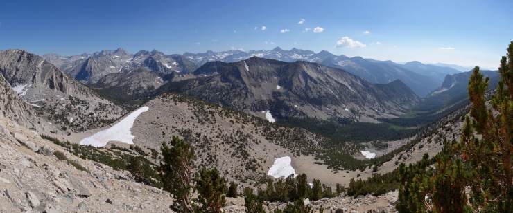
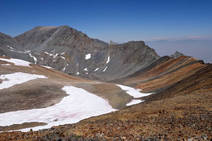
The ground was a loose mess and the pine dense where it did exist so the going had plenty of frustrations, but the views were absolutely incredible. The entire width of the Sierra was visible in one of the biggest panoramas I can remember. From Forrester Pass to Roads End with huge peaks filling in the middle. Forty minutes from the saddle, I crested the bulging slope’s horizon and caught a view of Charlotte Col. A gently rising slope on my side, and what looked like a cliff on the other.
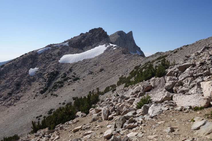
Eight minutes later, I was there, able to confirm that yes, it was a cliff (mile 9.5, 11,950ft). Trying to keep an open mind, my chest slowly tightened as I examined the north side. Truly, it was an easy class 3 scramble down the initial and steepest 30ft, but steep snow extended from there, shaded and firm, maybe 50°. An extended slide was guaranteed if I was stupid enough to try that. I ate some food, drank some water, and admired the view.

When I returned to the problem at hand, I noticed that there was a seam of exposed talus on the far left of the notch, running between the snow and a short rock ridge. It too ended in snow, but 30 yards lower and on a much more reasonable slope. I can handle that. The actual doing was comparatively easy. The initial downclimb was a little tricky while dodging snow, but the seam was wider than it had appeared and didn’t give me any trouble. At the bottom, a careful scoot delivered me safe across the snow to another patch of talus. By the time I reached the bottom of this, the angle was nothing to worry about. Out of the shade now, I found a standing glissade easy to control over minor suncupping.
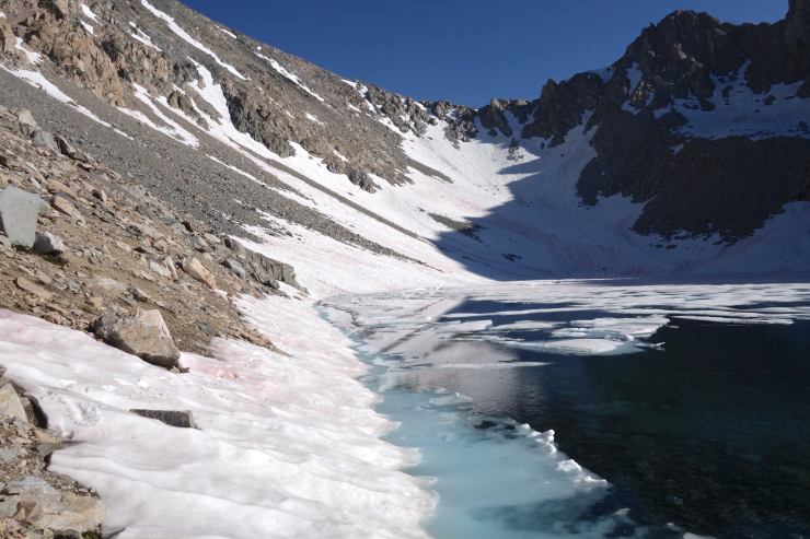
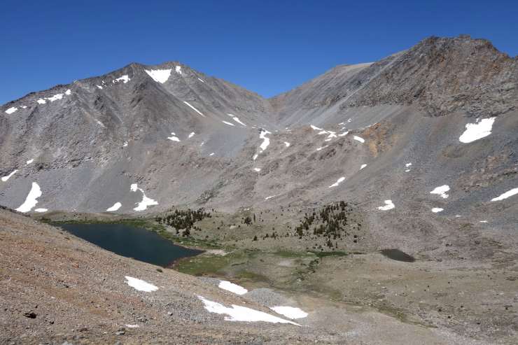
The tough part was over in 15 minutes. The next 25 were spent on a fun slip-slide around the snowy shores of a mostly frozen lake. When I hit the far side, I was ready to call it a day. A wide bench of polished granite provided ample camp choices with epic views north over Sixty Lake Basin and beyond. If that wasn’t reason enough, I was pretty sure I would be safe from mosquitos at this frozen altitude. I set up to cowboy on a patch of sand, under a clear sky with the sun about to set behind Sixty Lake Col (mile 10.5, 11,250ft). 5:30pm.

Morning. Sun, granite, snow, blue water, blue sky, Pop Tarts. I was moving by 8:30am, eager to see what I had earned with my adventuring yesterday. After 20 minutes of bench hopping I was wandering along a grassy lakeshore back among the trees. 10 minutes further, I walked through a small camp of bewildered gentlemen before finding the main trail through Sixty Lake Basin. The abundance of small lakes and connecting channels made this feel like the Venice of the Sierra. It also made the trail difficult to follow so I played hide and seek with it while swatting mosquitos from my legs.

If I hadn’t had big miles to cover, I really would have enjoyed my time among the lakes. A lot of corners to explore and answers to observe. The fishing is probably good too. As it was, I was anxious to nail my exit from the basin, cross country through Basin Notch to the PCT at Arrowhead Lake. I missed it badly. I got a good view out of my blunder, but had to backtrack and settle for a steeper descent to the trail. Nothing crazy, just a bonus mile and some extra gravel in my shoes. However, I was thrilled when I finally hit the beautifully manicured PCT (mile 15, 10,300ft).

This joy was short lived. Less than a half mile later at the outlet of Dollar Lake, I veered right onto the unmaintained Baxter Pass Trail. With freshly soaked feet, I began a long traverse north on the lower slopes of Diamond Peak. I immediately lost the trail, but could clearly see where I was headed so continued without protest. Wobbly talus interspersed with dense willow required thoughtful wandering, however. I picked up the trail again, which had paralleled above, when I turned east up the Baxter Creek drainage. Again, it’s usefulness was short lived and I decided to let it go to make my own way as it transformed into a small stream on the climb through dense forest. After some final fiddling around boggy meadows and short cliffs, I broke through the tree line into a wide basin where the big-ish Baxter Lake wallowed in a glacier-carved ditch, grassy north shore, talus south shore (mile 18.5, 11,080ft). Hardy mosquitos beat the breeze so that I was forced to don my headnet, but they could not prevent me from taking a plunge after inhaling a Clif Bar on my way around the lake.
The trail jiggled in tight switchbacks up steep talus immediately from the eastern shore. Mosquitos and living things disappeared except for the odd bunch of purple flowers. The trail crested this steep section into a hanging valley of streaking red and black rock. A few patches of snow lingered on the steepest sections, but the gradual ascent was straight forward on an easily followed trail. A surprising left turn pointed me up one last steep slope, and I was there, panting heavily on Baxter Pass (mile 20.4, 12,320ft). The views, incredible. Barren and colorful in a way that makes you more interested in geology than ever before. Lunar? Martian? Nah, this scene was as Californian as the beach, even if relatively few people are privileged enough to see it.
I crunched down the other side on a surprisingly good trail, switchbacking across a steep slope of black talus. The dramatic east face of Diamond Peak loomed large as I bottomed out near the North Fork of Oak Creek, 1,500ft lower. Willows and washouts immediately wore out their welcome, consistent and constantly confusing. Occasional cairns poked from the brush, but it was mostly a choose-you-own-adventure, although the general direction was obvious. Lower down, sharp scrub slowly shredded my bare legs. At least there was plentiful water.

After a few hours of this punishment, the trail entered a burn area, which actually opened things up and made the going easier. A crossing of the creek (mile 24.7, 8,400ft), potential sketchy with high water, was followed by a pleasant traverse on good trail among the snags, which afforded good views out to the Owens Valley. The final and sketchiest creek crossing came once the trail was firmly in the embrace of the desert. On a tip from another hiker, I found a downed tree spanning the torrent a few hundred feet upstream of the trail (mile 26.1, 6,900ft). I chugged a fresh liter, but didn’t hang around too long. I was hot, frustrated, and ready to be done. Though I suspected it was close, the trailhead remained hidden until I was practically in the parking lot (mile 27.2, 6,000ft). 5:40pm. I was toast, feet pummeled, legs perforated, but my car was there and I still had the key. Made it. I peeled off my sweaty clothes, then rolled, windows down, out of the lengthening shadows to the highway. Bike right where I left it, ice cream soon in hand. Well earned, I think.

Good readinng this post
LikeLiked by 1 person