
Sawmill Pass was the last Eastern Sierra pass on my list. There was a reason I had waited to explore this quiet access point, but there was no deferring it now. Like the other of the ‘Big 3 Brutal Passes’, Sawmill starts essentially in the desert and climbs 7,000ft in 9.7 miles making for one of the more difficult ways of accessing the backcountry. However, the rewards are maybeworth it. Difficult access from the east combined with no western access nurtures the existence of little visited pockets of pristine wilderness. The huge logistical and physical effort needed to link Sawmill with other trailheads keeps the region between Rae Lakes and Mather Pass essentially empty, except for hikers blowing through on the narrow JMT corridor. For a weekend trip, reaping these rewards is impossible and so it hardly seemed worth the effort, but it was finally time to fill this blank spot on my map and see what all the moaning was about.

I have to admit, it is pretty disappointing to arrive at the Sawmill Pass trailhead. Even its reputation hadn’t prepared me for just how ‘in the desert’ it is at 4,600ft. But the road ended, and I started walking. Navigation was a little tricky over the sandy plain, but it was clear where I was headed. Before long I was on a good trail climbing steadily through sagebrush. The trail was steep, with a few long switchbacks, so I gained altitude quickly before rounding a ridge to complete the final exposed traverse into Sawmill Canyon. No water, no trees seen yet, and at 2,500ft climbed and 3.2 miles hiked, my thirst was building. Fortunately it was a cool September which kept the temperatures reasonable even though I started at 9:30am. The Forest Service recommends a pre-dawn start during the height of summer. I would agree.
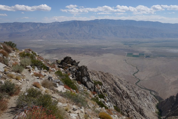
Everything changed when the trail hit the first water, a tributary of Sawmill Creek (mile 4.2, 7,250ft). First, there was water, which is great for hydration, but trees and the shade they bring became abundant. The trail remained extremely steep, but pleasant and interesting between blinding drips of sweat. Views opened up as I crested The Hogsback where I plopped down to cram calories and consider the building clouds. Perched on the decomposing remains of a toppled snag, I quickly grew chilled as wind whipped my sweat soaked shirt.

The trail leveled off at Sawmill Meadow (mile 5.7, 8,330ft), lush and green with knee-high grasses and probably the first suitable camping area encountered. Hinting at a recent torrent, the ground was exquisitely soggy despite the trail skirting through the treed perimeter. Dodging mud was fun and all, but I wasn’t too fussed when the trail began climbing again up to the shallow Mule Lake on the next bench. Another good effort on steep switchbacks got me kind of close to Sawmill Lake (mile 7.8, 9,970ft). Numerous use trails split towards the big and beautiful body of water and likely tucked away camp spots, but I followed the trail as it continued to climb on an arcing traverse around the northern shore, never getting within a stone’s throw.
Tree cover began to break as the terrain turned rockier and more alpine. Meandering up and through a few more scenic benches, I was actually surprised when I had nowhere left to climb. Topping out the final shelf, Sawmill Pass spread to the north, extremely wide, extremely flat, and extremely beautiful. Two signs sprouting from a sparse meadow strewn with boulders marked the official spot (mile 9.7, 11,347ft). Puffy clouds swirled above, but I wasn’t worried about them yet. After snapping some photos and eating some stuff, I tipped northward to see what I could find on the other side.

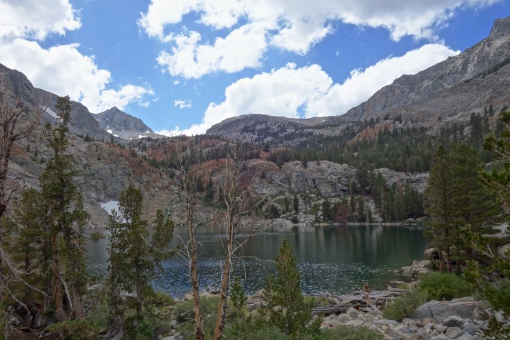
I soon veered away from the light trail as it entered Woods Lake Basin, aiming for Woods Lake or anything else that looked interesting. When I reached its shores, I knew I was home and set up camp in a well-used spot (mile 11.4, 10,700ft). Thunder rumbled and rain blew north, all safely west of my position, as I ate dinner and watched the sunset. A couple rouge droplets weren’t enough to get me to set up my tarp, though I fell asleep half expecting a rude awakening.

Morning, dry and clear. Free from any plans, I packed up and spent some time poking around the basin. Many lakes to swim, peaks to climb, corners to explore. Yet another glorious Sierra basin with virtually zero visitors. Yet another place to spend more than one night. I considered finishing the trail to its junction with the PCT, but quickly building clouds turned me around for the car instead. I hoofed it back over the pass into swirling puffs, exchanging friendly words with two hikers coming in (the only other people I met the entire trip).

Chased by rain and pulled by burrito lust, I made quick work of the descent through forest, then desert. Warm petrichor and damp sage filled my nose along the final switchbacks, virga unfurling above. My feet felt understandably pounded as I kicked through the final stretch of sand. 7,000ft is a long way down. Heck, it was a long way up! A lot of effort for one night, but better than not doing it at all. Happy for the visit. Happy to wait a bit before returning.

I enjoyed the description of your hike. My cousin and I just hiked up the Sawmill trail a couple weeks ago for the first time. I’m over sixty years old and only in decent shape. We were on the trail for six days and covered almost the same distance as your trip. At the end of our hike, we were both wondering if we’d ever want to put on a backpack again. After our soreness wore off and we reviewed our photos and videos, we both agreed that it was DEFINITELY worth it. It’s a beautiful area, and we had an amazing trip. Thanks for your description of the hike. The distance and elevation points were helpful. Best wishes.
LikeLiked by 1 person
Awesome, Jeff! I’m glad to hear that you had a good trip out there. I wish I had spent six days myself. That area definitely deserves slow movement and contemplation. It’s hard to beat that classic Sierra scenery and solitude. Did you see any other people out there?
LikeLike