
CDT Day 114 — October 17
Creede Cutoff Junction to Wolf Creek Pass (Pagosa Springs, CO)
Cozy Ridge Camp to Motel SOCO
Miles hiked: 14.3
Total miles: 1984
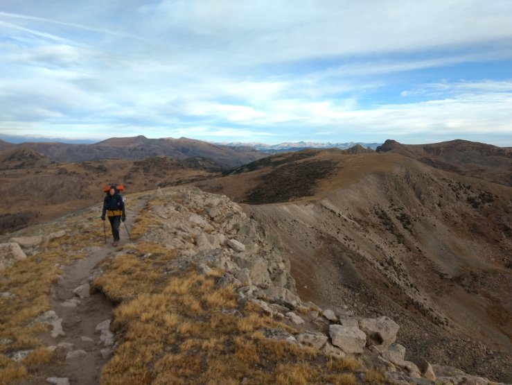
Farewell to the San Juans. One more climb to a high place, then easy basin hopping to Wolf Creek Pass and a ride to the town of Pagosa Springs, or Pag-town as the locals call it. My mind had clearly shifted to town mode already. All I could think about was food, but with a forced break, tried to be present one more time in these incredible mountains. What a stretch of trail. I am so grateful for the opportunity to traverse the San Juan highs and lows, which aren’t that low at all. High clouds and cold wind might be indicating a shift in the weather. If that’s the case, we really did just pull it off. Here’s to the mountains and a late winter!

The wind wooooed and whirrrred in the tree tops and along the ridge all around us all night, but it was perfectly calm at our spot, which enhanced the coziocity. I slept better than I had in weeks. I clambered out of the tent to an ominous yet beautiful scene of gray. High clouds blanketed the sky in a way not seen since our last snow. A shift in the weather? Sunrise was pretty great, then we got hiking.

A great hunger for burritos drove me up the final big climb above the trees. Walking along the ridge it seemed like we would reach the absolute high point, but instead took a sharp turn across the ridge and down into a protected east-facing basin with a big lake in the bottom. I felt a little strange. Maybe just cold and dehydrated. Maybe getting a cold. Maybe just worn out. We stripped off layers after a water break as the sun started poking through. 9 miles to the road.
Elaborate and intricately constructed breakfast burrito fantasies filled my time through more basins and trees. I stopped to lie in the sun and air my feet one last time at a particularly beautiful place that reminded me of northern Yosemite with a bundle of granite and tiny lake. I warmed in the sun. Savored the place.

Spice joined me, and then we were off. We followed the trail away from the highway up to the radio tower for some reason, then down to Wolf Creek Pass. I couldn’t tell if I was hearing a rushing stream or the rustling of dead leaves at times. A sign of the season. A guy out for a day hike saw me coming and offered a ride into Pagosa Springs before I could even ask. Good conversation on the ride down the mountain, back into the world of golden aspen and green things.
We didn’t dig the vibe at the first motel we checked out and hoofed it through old town to a different one, stopping at Subway along the way for provisions. It’s no burrito, but it will do. Motel SOCO felt like home immediately as we walked through the yard with corn hole and disc golf. People sitting in the lounge cheered us on. Our room came at the right price and with the right amenities.
Spice and I were both too tired to get motivated to do chores so the list slowly shortened without any action. Laundry? We’ll just wash our clothes in the shower. Dinner? Let’s just get what we need at the grocery store. Hot springs? Eh, a shower is good enough for me.
Our friendly neighbor saved us a tough hitch in the dark to buy groceries. He took us to the store, waited for us to shop, then took us back. “Nothing better to do,” he said. There is always something better to do than sit in a Walmart parking lot, but his kindness was much appreciated. We collapsed back into our room, just enough energy to spread a towel on the bed to catch our crumbs. Drama on Terrace House captivated our attention while we shared hummus and bread and carrots and ice cream and a burrito and cereal. A call home, then sleep. Too tired to fully process the San Juans. I’ll leave that for later. Just happy to be full and warm now. That’s good enough. In this moment, it feels like that’s all I’ve ever needed.

Amazing sunset views. Food oh man… I dont feel complete if I skip my meal at least for a few hours not to mention after any type of physical activity =D Walking up and down the mountains is the mortal recipe for the hiker’s hunger that can never be satisfied. I am so happy you finally reached a place to resupply and enjoy simple pleasures in this mysterious process called life.
In addition to my comment under the ”Day 107” could you allow me please carry on with excessive questioning as I crave for finding out some more details. First… In case of the PCT, there is an official website, where you apply for all the permits, find out about the route, conditions, hazards etc. What is worthy of mentioning is that they have the page with all the fire information and DETOURS around those wildfires. They give you maps and reroute paths if there are alternates available. Now… we dont have wifi on the trail. Website keep it up to date which is nice but on the trail it is of no use. How do you find out about fires AND detours right on the fly while you are hiking? It is a mystery to me. Especially in case of cdt. I know it doesnt pertain to your current position but in general… Do you just see the smoke, then you see a sign which says – ”CLOSURE” and next thing you turn around.. Or.. I cant figure this out =D How does it work. Because in the majority of cases there are ”official” alternates.. or how to know if the alternates are ”official” after all ))) This moment is completely blank/grey area to me.
Next thing (I m sorry I have more), I d be grateful if you could tell how many people is the optimal number for hiking (from your standpoint). If you ask me two (2) is more than enough. Solo hiking is crazy hiking imho but solo backpackers will vehemently disagree with me. I prefer to do everything solo but I recognise that hiking solo in the wilderness is kind of nuts first of all from the safety standpoint. All other aspects can be doable in proud loneliness but health and safety protocol is the priority number 1 (thats just the way I see it from my humble vantage point). More than 2 in my view is overabundance and there will not be that experience of solitude, 2 people in nature normally exist together but alone at the same time. However there are sections with snow-packs, it is very well known that the more people are traversing the snowpacks the more chances are that a potential victim can be found if the avalanche slides for example… I dont know for sure and Im willing to be corrected on this account. But never alone for sure, especially high elevations during unstable seasons.
And the last. Are towns along the cdt dodgy? Have you felt unsafe entering any of them (as far as I know down there in NM by all accounts some towns are in some way sketchy). Hikers is an easy target which gets us back to the previous point that we need a fellow traveller. I might be exaggerating all the hazards… but these questions must be ticked off the list))) If you please.
Thanks for bearing up with all these walls of text.
LikeLiked by 1 person
Totally agree about the food. If I’m not hungry after a hard day of hiking, then it worries me. Even if I don’t feel bad at the time, I know I’ll pay for it later when my body hasn’t fully recovered. Lack of appetite is a great indication that something isn’t quite right and I always try to listen to that.
To answer your first question, that is a question I found myself asking while hiking into some thick smoke on the PCT. “How do I know that there isn’t a fire right in front of me?” For the PCT, there is a super amount of trail condition information on the internet. The PCTA is really good about fire closure updates, but there is also a ton of discussion on Facebook and other social media platforms. During fire season, the talk of the trail is of fires and reroutes. Everyone is talking about it. But you’re right, the information only helps if you can access it and often times there is no way to do that from trail. On trail, it comes down to common sense. Stay alert when there is smoke, know the weather forecast, know the terrain and if there is a safe place to hide, and don’t be afraid to turn around, especially if there is a closure sign across the trail. There’s no elegant solution and I think it comes down to personal accountability. Mother Nature can be harsh and unforgiving. Dangerous in so many ways. Getting caught in a fire could definitely happen, but I think that it must be super rare. I’ve never heard of it happening to anyone before. For the CDT, I’m not sure where the information comes from about fires and detours. Thankfully fires were not an issue for us at all so we never needed to dig around for information. And doing anything “official” is much less important on the CDT it seems than on the PCT. The whole CDT is just a huge “hike your own hike” adventure. And there is so much roadwalking anyway, that adding some more pavement miles to get around a fire isn’t a huge deal. Hikers just do what they have to do.
In my opinion, the number of people in a hiking group is totally base on personal preference for the majority of hiking on trails. I really enjoy hiking solo myself, but the experience can be so much richer when shared with friends. Obviously I’m having a great time hiking the CDT in a pair, but I don’t think that’s the perfect number or a bad number. I had a great time hiking the PCT mostly solo. The Haute Route in a group of four was an absolute blast. The CDT as a pair works for Spice and me, but it is definitely nice to have other hiking buddies around here and there to keep things fresh. I agree that safety is the greatest argument in favor of a larger party, but I think that only demands consideration in sketchy conditions found in the shoulder seasons or winter. Snow and river crossings are usually safer with more people around just in case something goes awry. On a good trail in summer? An observant hiker doesn’t have much to fear from going solo. Personal Locator Beacons (PLBs) such as the SPOT are to be considered as well as a safety net, although there can be no substitute for possessing the right skills and experience, of course. All this said, I think that the experience level of the party needs to match the conditions. 1,2,3, or more people. Spring, summer, fall, winter. Does the group possess the skills to deal with the stuff that can go wrong? Beyond that, it’s totally personal.
To your last question, there are definitely dodgy places along the CDT and there have been times when I felt unsafe, though for the most part I have felt totally safe. I am a white male too, fit and in my prime. Not an easy target. I know for certain that women and people of color sometimes feel at risk in some of the more depressed towns. We have seen a lot of the angry white America that is downright unwelcoming to people unless they look like I do. And of course I must mention that SpiceRack had her pack stolen in near South Pass City. There are sketchy characters anywhere humans live and the CDT is no exception. I don’t want to ruffle any feathers, but there is a prominent gun culture most places outside of Colorado. Drunk folk with guns in the middle of nowhere along a dirt road, hunters hiding in the mountains, there are a lot of guns out here. I would feel safer with grizzly bears in the woods than hunters with guns. In general, I feel that all hazards are exaggerated, but that doesn’t mean they don’t exist. Common sense is as important in the rundown parts of the CDT as it is in San Francisco or London. Just keep an eye on that backpack!
I’m getting sleepy, but I hope I addressed your questions adequately. Feel free to ask for more clarification though. And keep the questions coming!
LikeLike
You are correct, dodgy characters can be met anywhere AND YET when you meet them in the middle of nowhere… laws dont apply at all this is first, and second there is no police or an ambulance or even a random passer-by to rely on. Ok. Lets leave these concerns alone, most of them as you said , refer strictly to common sense and personal accountability. (cant resist saying that stealing a hiker’s pack is clearly a downright despicable act). Ok… What I wanted to get back to… fires. So, Let me please backtrack and ask you to elaborate on -”know the weather forecast”, does it include wind strength and direction of it? Rain? And ”Know the terrain and if there is a safe place to hide”. May I ask what type of the terrain can be more safe if there is a wildfire somewhere around and what can we consider a safe place to hide? My guess would be that thick forest is unsafe place any way you look at it. These poor beautiful pine trees burn like matches. And smoke itself can be harmful.. have you ever heard of/seen any hiker wearing masks with a filter or respirators?
As for the rest I am so grateful to you for addressing all my queries.
thank you for your contribution into my preparedness level.
Certainly the huge wall of text is coming your way soon. Ill try to put it together as concise as I can and make it my final (maybe) and major avalanche of questions which are pleading for the answers. ;D
Until the next time,
Yours sincerely.
LikeLike
It is November 9 ! It has been a while since the last post so hopefully things are going smoothly.
LikeLiked by 1 person
Yep, I’m a total bum, haha. Sorry for the delay, they’re coming. Don’t worry, nothing is smooth out here, but we’re moving steadily south. Day by Day, mile by mile, step by step.
LikeLike